
ALABAMA OUTDOOR RECREATION 
Alabama is one of the 48 continental U.S. states, located in the Southeast between Mississippi and Georgia. The state stretches from the Appalachian Mountains in the north to fertile valleys, pine forests, and sandy beaches along the Gulf of Mexico. It borders Tennessee along the 35th parallel north and Florida to the south, with a small coastal lobe opening onto the Gulf.For thousands of years, Indigenous peoples lived along Alabama's rivers. The first Europeans to explore the area were Spanish expeditions in the mid-16th century. About 150 years later, French settlers founded Old Mobile (Fort Louis de la Louisiane), the first European settlement. The region passed to Britain in 1763, to the United States in 1783, and on December 14, 1819, Alabama became the 22nd state of the Union.
BEST TIME TO VISIT ALABAMA
Alabama's climate is humid subtropical, with long, hot, and humid summers and mild winters. Rainfall is abundant year-round, heaviest in the south, and the state is known for severe weather, including frequent spring thunderstorms and tornadoes as well as the risk of hurricanes along the Gulf Coast. Tornadoes can occur in the region any time of year, but the primary tornado season is from March through May.
GETTING AROUND IN ALABAMA
Alabama's landscape is geographically diverse, encompassing coastal plains, rolling hills, and forested areas. Along its southern Gulf Coast, there are sandy beaches and marshy wetlands. Inland, the terrain rises into gently rolling hills, and the northern part of the state is characterized by the foothills of the Appalachian Mountains. These diverse landscapes offer a range of outdoor opportunities, from water activities along the coast to hiking and exploration in the wooded hills. The state occupies an area of 135,767 km² (52,420 sq mi), making it somewhat larger than Greece (131,957 km²). Compared with other US states by area, Alabama is six times larger than New Jersey, but it would fit into Texas about five times. Nearly 70% of Alabama's landscape is covered by forest.
Alabama's landscape offers five major physiographic regions; all areas are sections of the far greater geographic regions of the Eastern and Southeastern United States:
I. The Highland Rim section in the northwest and north-central Alabama is the southern portion of the Appalachian Highlands.
II. To the southeast of the Highland Rim rises the dissected tableland of the Cumberland Plateau (aka Allegheny Plateau), the southern part of the Appalachian Plateau.
III. Further southeast stretches out the belt of the Appalachian Ridge and Valley, a region with ridges along valleys in between, like the Red Mountain ridge that separates the Jones Valley from the Shades Valley south of Birmingham (AL).
IV. Between the Ridge and Valley area and the Atlantic Seaboard fall line dominates the Piedmont Upland Alabama's landscape, a triangular shaped area with rolling hills in the central eastern part of the state.
V. The Coastal Plain province of Alabama is the largest geographic region (about 60%) in the state. It is a mostly flat region, but here and there, it offers some change in the landscape, rounded and eroded hills, cuestas, and Flatwoods; and the are the floodplains of the Alabama and Black Warrior rivers.
RIVERS IN ALABAMA
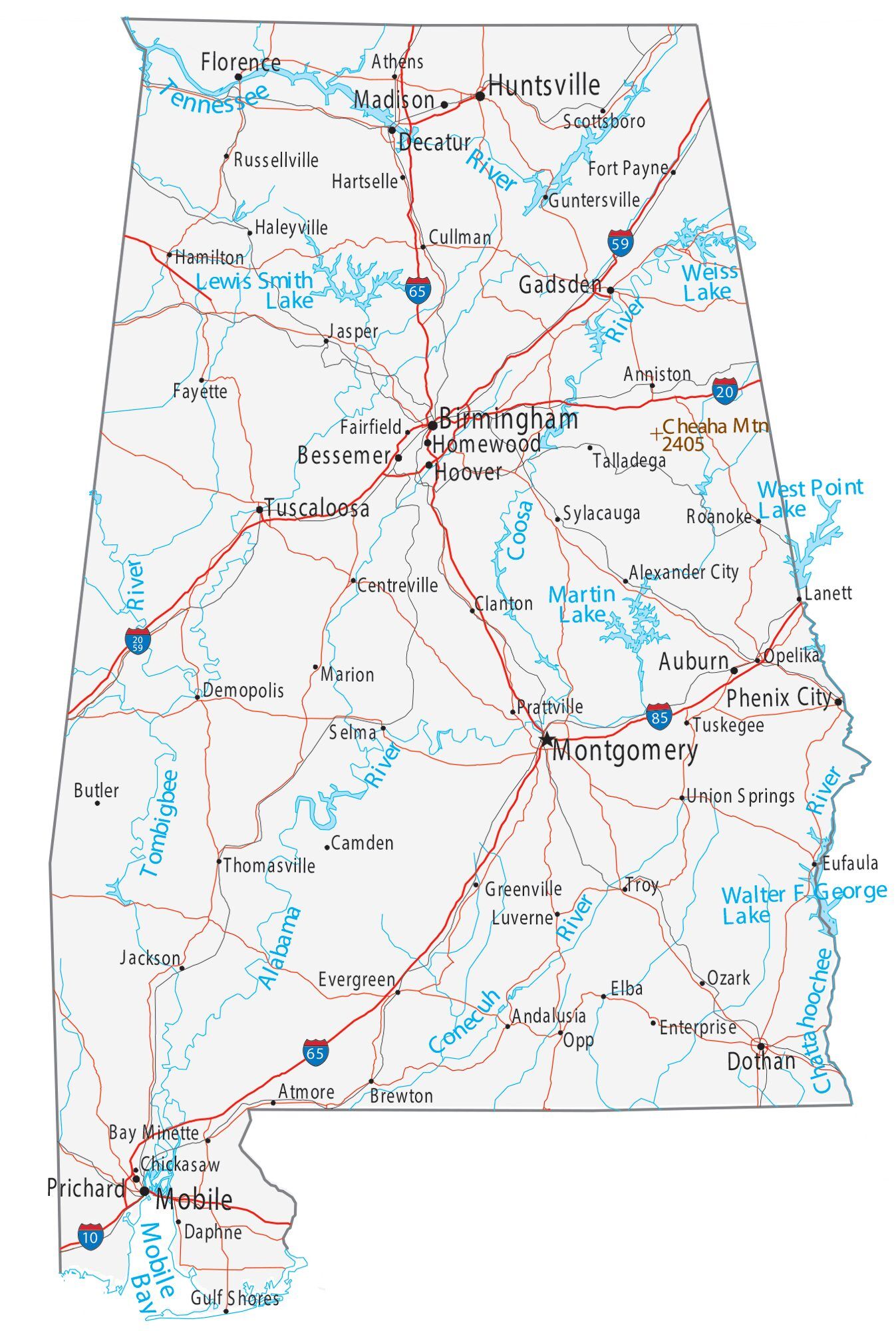
Principal rivers in Alabama are the Coosa River, which becomes the Alabama River, which is then fed by its tributaries, the Tallapoosa, and the Cahaba rivers.When the Tombigbee River joins the Alabama, the river changes its name again to Mobile River.The Tennessee River, the largest tributary of the Ohio River, crosses Alabama in north.The Chattahoochee River forms a section of Alabama's border with Georgia.The Black Warrior River empties the largest drainage area that lies entirely within Alabama.LakesMajor lakes are Lake Guntersville, a reservoir along the Tennessee River; it is Alabama's largest lake.Wheeler Lake, Alabama's second-largest lake, is a human-made lake along the Tennessee River.Walter F. George Lake (aka Lake Eufaula) is a reservoir formed on the Chattahoochee River along the state line between Alabama and Georgia.Lake Martin is a reservoir along the Tallapoosa River; Pickwick Lake is another reservoir along the Tennessee River, and Lewis Smith Lake, a barrier lake on the Sipsey Fork of the Black Warrior River.
HIGHEST POINT IN ALABAMA
In the northeastern corner of the state is the Sand Mountain, a sandstone plateau, part of the southern tip of the Appalachian mountain chain. The highest point in Alabama is Mount Cheaha at 735.5 m (2,413 ft), located in Cheaha State Park.
FOOD AND DRINK IN ALABAMA
Mobile is known for fresh Gulf seafood, oysters, shrimp, crab, and catfish, prepared in Creole and Lowcountry styles. The city’s signature dishes reflect French, Spanish, African-American, and Native cooking traditions layered over 300+ years. Gumbo is arguably Alabama’s most iconic dish, built on a French roux base, Native-taught file and okra, and Gulf seafood. It’s also the dish that best represents Mobile’s history, born from the collision and adaptation of multiple cultures.